Indian diaspora provides key link between India and Saudi Arabia, says former foreign minister

Former Indian Foreign Minister and president of the India Islamic Cultural Center Salman Khurshid (4R), AIMIM Bihar president Akhtarul Iman (3R) in Riyadh during an interaction with the Indian diaspora. (Supplied)
Short Url
Updated 08 February 2025
Follow

Indian diaspora provides key link between India and Saudi Arabia, says former foreign minister

  • Salman Khurshid, president of the India Islamic Cultural Center, visits Riyadh to discuss with Indian expatriates their experiences of living and working in the Kingdom
  • Akhtarul Iman, of the Bihar Legislative Assembly, says authorities in India have failed to address the concerns of Indian Muslims in an appropriate manner

RIYADH: Salman Khurshid, president of the India Islamic Cultural Center and his country’s former foreign minister, said Indians living and working in Saudi Arabia play a key role in relations between the two countries.

He added that he and his team are working on implementing changes and reforms at the cultural center to improve the support and services it provides for all Indians, not only in India but in other countries.

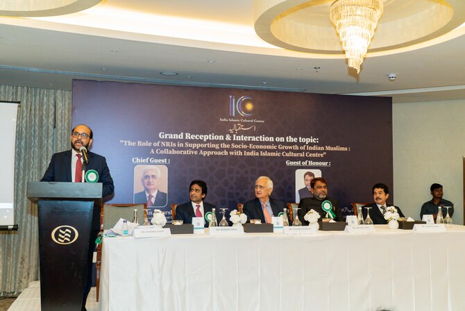
Khurshid, who was elected president of the center in August last year, was visiting Riyadh for an event on Friday during which he discussed with Indian expatriates their experiences of living and working in the Kingdom.


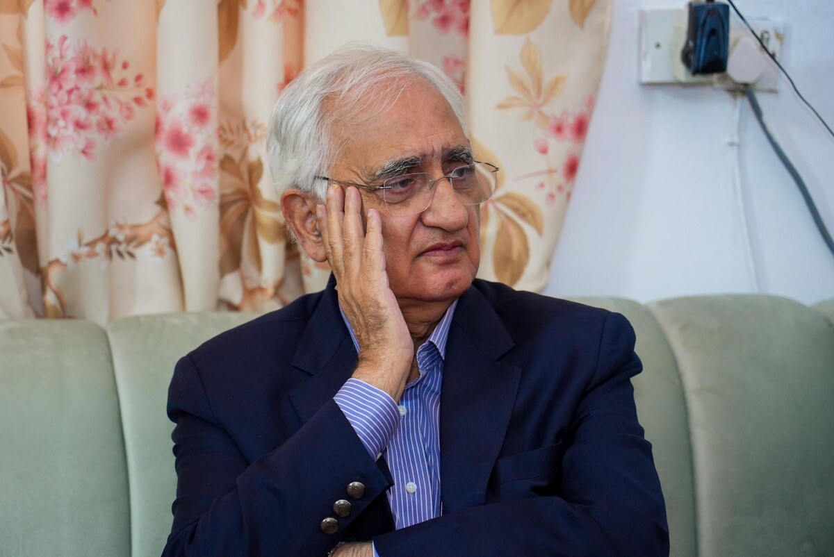
Former Indian Foreign Minister and president of the India Islamic Cultural Center Salman Khurshid during media interaction in Riyadh on Friday. (Supplied)

“I am in here to interact with the Indian community and discuss the ground realities,” he said. “They are keen to know about the developments in India.

“I am very pleased that the IICC is in focus, people are looking at what possibilities there are, and how much we can develop the organization as a hub that links different parts in the world and connects with how important it is for that dimension of the Indian culture and the Indian society to be understood in the world.

“The Indian diaspora in Saudi Arabia can provide an important bridge between the people of India and the people of Saudi Arabia, and this has been an important aspect for successive governments in India.

“We will brainstorm on key issues and ground realities, we will talk about those issues and what positive contribution can be made by people who have left their homes and families to come out into the world and make a mark with their presence here in the Kingdom.”

Prime Minister Indira Gandhi laid the foundation stone of the center’s headquarters in New Delhi on Aug. 24, 1984. The aim of the organization was to promote understanding among people of different religions and aid the cause of national integration. It was inaugurated by Congress party president Sonia Gandhi on June 12, 2006.

Regarding possible changes and development of the organization, Khurshid said there are plans to establish branches in states across India, and beyond, to support the decentralization and democratization of the center.

“It’s not just about chapters in different parts of India but also in other countries, as IICC overseas chapters, (for example) in Saudi Arabia,” he added.

“My view is that there should be chapters and we should support those chapters, but if people want fully fledged centers to be set up in states, I would say they should be affiliated centers supported by local members. Members from Delhi cannot control centers in the states, it must be truly democratic.”


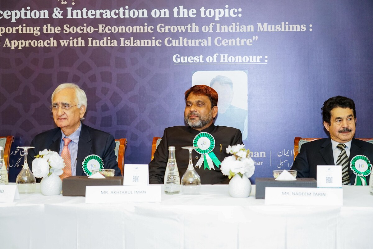
Former Indian Foreign Minister and president of the India Islamic Cultural Center Salman Khurshid, AIMIM Bihar president Akhtarul Iman in Riyadh for an interaction with the Indian diaspora. (Supplied)

Khurshid was joined at Friday’s event by Akhtarul Iman, state president of the All India Majlis-e-Ittehad-ul-Muslimeen who represents the constituency of Amour in the Bihar Legislative Assembly. He said it is the responsibility of the government and state authorities to protect the lives, property, honor and safety of all Indian citizens, yet Muslims have increasingly been targeted by those who wish to spread fear among them.

In the past decade, he added, there has been an increase in cases of injustice and atrocities committed against Muslims under the rule of Bharatiya Janata Party-led central and state governments, and the leaderships of both the Rashtriya Janata Dal and the Janata Dal (United) parties have also failed to address these issues in an appropriate manner.

“They ask Muslims for support but fail to address their concerns,” Iman said, adding that his party is committed to ensuring that the grievances of all Indian Muslims who have faced problems since 2014 are addressed.


What new technologies are revealing about the Silk Road’s forgotten landscapes

Updated 17 January 2026
Follow

What new technologies are revealing about the Silk Road’s forgotten landscapes

  • Drones and digital tools are allowing archaeologists to map vast areas in hours rather than months of ground surveys
  • In Saudi Arabia, aerial mapping has uncovered dense prehistoric and Bronze Age sites previously thought to be empty

DUBAI: Across the deserts and mountain valleys of the Arab world, drones are now doing work that once took teams of archaeologists months to complete.

In northern Saudi Arabia, for example, aerial surveys can map an entire ancient settlement in minutes, revealing faint outlines of walls, pathways and structures hidden beneath the surface.

These images are later turned into 3D models — part of a growing effort across the region to use technology to trace old trade routes, map forgotten sites and better understand how people once moved across Arabia and beyond.

Much of this work is connected to renewed interest in the Silk Road and the networks that once linked Arabia with the wider world.

Harrat, Khaybar. (Supplied)

The Silk Road refers to a network of ancient trade routes that linked East Asia with the Middle East, North Africa and Europe for more than 1,500 years.

Rather than a single road, it was a vast web of caravan paths and maritime corridors connecting cities from China and Central Asia to Iran, Iraq, the Arabian Peninsula, the Levant and the Mediterranean.

Along these routes, merchants, scholars and travelers exchanged goods such as silk, spices and metalwork, as well as ideas, technologies and cultural traditions that shaped the development of the wider region.

In more recent times, scholars, students and heritage authorities across the Middle East and Central Asia are increasingly relying on drones, laser scanning, photogrammetry and satellite analysis to document archaeological landscapes.

In Saudi Arabia’s AlUla and Khaybar regions — now considered some of the world’s densest concentrations of prehistoric and Bronze Age structures — drone surveys have helped researchers record sites that would otherwise remain inaccessible.

Dr. Hugh Thomas, a lecturer in archaeology at the University of Sydney and co-director of the Prehistoric AlUla and Khaybar Excavation Project, says the scale of the Saudi landscape makes aerial work essential.

“Saudi Arabia contains an exceptionally dense archaeological landscape distributed across a vast geographic area,” he told Arab News. “Drone-based surveys allow large volumes of archaeological data to be collected efficiently.” 

A Neolithic mustatil next to a Bronze Age pendant burial in Kaybar. (Supplied/Mat Dalton)

Indeed, many structures sit on steep or remote terrain that ground teams cannot easily reach. This shift to aerial archaeology has also revealed details that would be almost impossible to see from ground level.

Thomas notes that researchers have long suspected a link between water sources and Neolithic mustatil structures, which date back approximately 7,000 years. In 2020, drone images captured by his team near Khaybar also strengthened theories linking mustatil to water sources.

“The drone images revealed that recent rains had settled in specific parts of wadi valleys, exactly where the mustatil were built,” he said. Since then, multiple surveys and peer-reviewed studies have supported this connection, with many mustatil shown to point directly toward water.

In parallel, new technologies are reshaping how archaeologists understand the wider landscape. Thomas says tools such as drones, satellite imagery and 3D modelling allow researchers to document vast areas quickly and at far higher resolution than ever before.

These approaches “enable the rapid, cost-effective documentation of this vast and previously understudied landscape” and create permanent digital records that support long-term monitoring and analysis, he said.

This has been transformative for understanding past movement and land use.

Remote sensing work in northern Saudi Arabia has revealed extensive Bronze Age funerary avenues — pathways lined with monumental tombs, running for thousands of kilometers and linking major oases such as Khaybar, Al-Hait and Al-Huwayyitt.

Drone surveys and 3D models have allowed researchers to classify tomb types more accurately and identify where excavation would yield the most useful results. Thomas says these techniques directly contributed to one of the project’s most significant achievements.

“This has ultimately assisted us with our most recent paper, where we were able to publish the C14 dates of remains found in 40 Bronze Age tombs, helping us understand when these tombs appeared on the landscape and how they developed over time,” he said.

While international collaborations play a central role, Thomas says long-term progress in the Kingdom depends on building local capacity.

He says contributions from Saudi researchers, students and even members of the public are becoming increasingly important.

Archaeologist Don Boyer measures a tower of stones next to a 525m long Mustatil in Khaybar. (David Kennedy)

“Local researchers, students, and members of the public are taking photographs of archaeological sites and sharing them digitally,” he said. “Each image provides a lasting record of archaeological remains.”

In Saudi Arabia’s AlUla, one of the region’s most active archaeological hubs, the Royal Commission for AlUla has supported wide-ranging surveys that combine aerial photography, remote sensing and targeted excavation.

Published research from the AlUla and Khaybar Aerial Archaeology Project describes how thousands of structures — from ancient hunting traps to tombs and settlements — have been recorded using these methods in recent years.

“We’re seeing landscapes we did not even know existed before this kind of work began,” said archaeologist Dr. Rebecca Repper of the University of Sydney in an RCU briefing. 

“Technology is helping us reassess northern Arabia’s role in long-distance connections.”

Recent research across Central Asia shows how drones and LiDAR, a remote-sensing technology used to create extremely accurate 3D maps of landscapes, buildings, or buried features, are transforming the study of Silk Road-era landscapes.

In Uzbekistan, a team led by Dr. Michael Frachetti — an archaeologist at Washington University in St. Louis, who specializes in ancient mobility systems — used drone-mounted LiDAR to scan remote high-altitude terrain, revealing two previously undocumented medieval cities, Tugunbulak and Tashbulak.

Researchers excavate medieval pottery at the newly rediscovered medieval Silk Road city Tugunbulak located in the mountains of southeastern Uzbekistan June 8, 2022 (Michael Frachetti)

A 2024 peer-reviewed study, “Automated analysis of high-resolution lidar traces large-scale medieval urbanism in highland Central Asia,” details how these surveys exposed plazas, fortifications and settlement layouts previously invisible from the ground.

In southeast Kazakhstan, a 2021 study in the journal Applied Sciences shows how UAV photogrammetry helped map irrigation networks, settlement traces and burial mounds linked to medieval trade and pastoral routes.

Together, these findings demonstrate how high-resolution aerial mapping is reshaping our understanding of the landscapes and movement patterns that framed the Silk Road.

For governments, these discoveries are more than scientific. UNESCO describes the Silk Roads as a shared heritage space where cooperation is critical, and regional countries have increasingly embraced cross-border research partnerships.

In Saudi Arabia, AlUla’s collaborations with universities including Oxford, Bologna and the French National Centre for Scientific Research reflect a growing diplomatic interest in cultural research.

These partnerships have generated shared excavations, joint field schools and open-access databases — opportunities that were rare in the region two decades ago.

Digital access is also reshaping how the public engages with this history.

The International Dunhuang Project, a global consortium led by the British Library and multiple Asian national libraries, has digitized hundreds of thousands of manuscripts, murals and archaeological fragments linked to the Silk Road.

Its open platform has become a major educational resource for schools and researchers worldwide.

A LiDAR image of Tugunbulak shows a dense settlement along a ridge. (Michael Frachetti)

In AlUla, digital reconstructions and virtual models are increasingly used in classroom activities and community programs.

Youth involvement is part of this shift. In Saudi Arabia, RCU’s assorted heritage guardian programs introduce young people to survey techniques, basic archaeology and remote-sensing tools, helping train a new generation of community researchers.

In parts of Central Asia, student volunteers often support field surveys and digital documentation under national heritage ministries and international missions.

Across deserts, mountains and oasis towns, a fuller picture of ancient networks is beginning to emerge. Every drone flight reveals structures long buried under sand and stone.

“On the plateau, we found a hidden valley with large mounds and undulations on the surface,” Frachetti explained in a Washington University Magazine feature about his team’s drone-assisted work.

“It was obvious, both in person and on the drone-acquired surface model we created, that we had stumbled across something much larger and different from the typical campsite we had expected.”

Recent archaeological work has discovered a fortified 2.6-hectares Bronze Age town (al Natah) in Khaybar oasis (dating around 2400 BCE- 1300 BCE). (RCU)

Meanwhile, every 3D model helps trace how people once traveled, traded and settled across continents.

And every partnership — whether in AlUla, the Gulf, or Central Asia — reinforces the idea that this heritage connects far more than a single nation.

The Silk Road’s story is being rediscovered not through speculation but through data, satellites and the work of a generation that is documenting the past with new precision.