BEIRUT: The Lebanese militant group Hezbollah has confirmed that Israel killed a top commander after a rare strike in Beirut on Tuesday.
The Iran-backed group said earlier that Fouad Shukur was in the building during the attack, and they were searching for him in the rubble to determine his fate.
Hezbollah’s announcement comes after an overnight strike in Tehran that killed Hamas leader Ismail Haniyeh, which Hamas and Iran blamed on Israel.
Israel said late Tuesday it had killed Shukur, who it said was behind the weekend rocket attack in the Israeli-occupied Golan Heights that killed 12 youths. The United States also blames Shukur for staging and planning a bombing of a Marine Corps barrack in Lebanon in 1983 that killed 241 American service members.
The Lebanese Health Ministry said at least five civilians — two children and three women — died in the strike in a busy neighborhood where Hezbollah has political and security operations.
Israel and Hezbollah have exchanged fire since Oct. 8, a day after Hamas attacked southern Israel and sparked the Israel-Hamas war in Gaza.
On Tuesday, Israeli carried out a rare strike on Beirut, which it said killed a top Hezbollah commander who was allegedly behind a weekend rocket attack that killed 12 young people in the Israeli-controlled Golan Heights.
Hezbollah didn’t immediately confirm the commander’s death. The strike came amid escalating hostilities with the Lebanese militant group. An Israeli official said the target was Shukur whom the US blames for planning and launching the deadly 1983 Marine bombing in the Lebanese capital.
The official spoke on condition of anonymity because he was not authorized to discuss the details of the strike with the media. Shukur is also suspected in other strikes that killed Israeli civilians.
Though Hezbollah issued a rare denial of involvement in the rocket attack Saturday in the town of Majdal Shams, Israel is holding the militant group responsible. “Hezbollah crossed a red line,” Israeli Defense Minister Yoav Gallant posted on the platform X shortly after Tuesday’s strike.
The two sides have exchanged near-daily strikes for the past 10 months against the backdrop of the war in Gaza, but they have previously kept the conflict at a low level that was unlikely to escalate into full-on war.
Lebanon’s public health ministry said Tuesday’s strike wounded 74 people, some of them seriously. The wounded were taken to nearby hospitals. Bahman Hospital near the site of the blast called for blood donations.
Lebanon’s state-run National News Agency reported that the strike was carried out with a drone that launched three rockets.
“The Israeli enemy has committed a great stupid act in size, timing and circumstances by targeting an entirely civilian area,” Hezbollah official Ali Ammar told Al-Manar TV. “The Israeli enemy will pay a price for this sooner or later.”
Lebanese caretaker Prime Minister Najib Mikati condemned the Israeli attack, saying it hit a few meters from one of the largest hospitals in the capital.
The office of Israeli Prime Minister Benjamin Netanyahu did not immediately release a statement, but minutes after the strike sent a photo of the prime minister with his national security adviser and other officials.
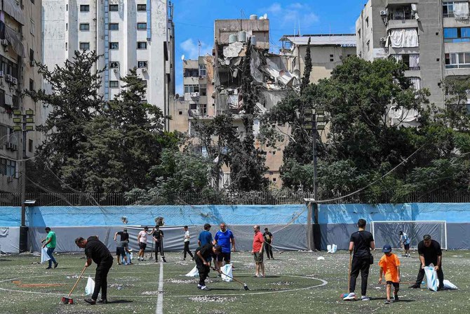
The airstrike on Beirut’s southern suburb of Haret Hreik — a crowded urban neighborhood where Hezbollah has political and security operations but which is also full of small shops and apartment buildings — damaged several buildings.
It was not immediately clear if any Hezbollah official was hit, a Hezbollah official said. A Lebanese military intelligence official said they had no information when asked by The Associated Press whether a senior Hezbollah security official had escaped the airstrike.
Both officials spoke on condition of anonymity in accordance with regulations.
The strike hit an apartment building near to a hospital, collapsing half of the targeted building and severely damaging one next to it. The hospital sustained minor damages, while the surrounding streets were littered with debris and broken glass.
A forklift was in the middle of the street, reaching to the top floors of the destroyed building, while utility crews removed fallen power lines. Crowds gathered to inspect the damage and check on their families. Some of them chanted in support of Hezbollah.
Paramedics could be seen carrying several wounded people out of the damaged buildings.
A resident of the suburb whose home is about 200 meters (yards) away said that dust from the explosion “covered everything,” and that the glass in his son’s apartment was broken.
“Then people went down on the streets,” he said. “Everyone has family. They went to check on them. It was a lot of destruction.” He spoke on condition of anonymity out of concern about his security at a tense moment.
Hassan Noureddine said he was riding his motorcycle near the building when he heard the sound of two explosions. “It looked like a strike from a drone and not a jet,” Noureddine told the AP near the site of the attack.
Despite fears of escalation and a strike in recent days, Noureddine said that he and other people he knows in the area are not fazed and that their spirits are high.
Talal Hatoum, a local official with the Shiite Amal Movement, Hezbollah’s key political ally in Lebanon, said Tuesday’s attack marked a shift in the rules of engagement in the conflict because it caused a significant number of civilian casualties.
The last time Israel targeted Beirut was in January, when an airstrike killed a top Hamas official, Saleh Arouri. That strike was the first time Israel had hit Beirut since the 34-day war between Israel and Hezbollah in the summer of 2006.
Israel had been expected to retaliate for the strike in Majdal Shams, but diplomats had said in recent days that they expected the response to stay within the boundaries of the ongoing low-level conflict between Hezbollah and Israel without provoking all-out war.
Many of them had not expected that Israel would hit Beirut, which might elicit a strike by Hezbollah on a major population center in Israel.
The United Nations’ special coordinator for Lebanon, Jeanine Hennis-Plasschaert, said in a statement that she was “deeply concerned” by the strike and called for “calm to prevail.”
US Vice President Kamala Harris said Israel “has the right to defend itself against the terrorist organization,” referring to Hezbollah, but added, “We still must work on a diplomatic solution to end these attacks, and we will continue to do that work.”
Hezbollah confirms that top commander was killed in Israeli strike in Beirut
https://arab.news/gte64
Hezbollah confirms that top commander was killed in Israeli strike in Beirut
- Hezbollah’s announcement comes after an overnight strike in Tehran that killed Hamas leader Ismail Haniyeh, which Hamas and Iran blamed on Israel
What new technologies are revealing about the Silk Road’s forgotten landscapes
- Drones and digital tools are allowing archaeologists to map vast areas in hours rather than months of ground surveys
- In Saudi Arabia, aerial mapping has uncovered dense prehistoric and Bronze Age sites previously thought to be empty
DUBAI: Across the deserts and mountain valleys of the Arab world, drones are now doing work that once took teams of archaeologists months to complete.
In northern Saudi Arabia, for example, aerial surveys can map an entire ancient settlement in minutes, revealing faint outlines of walls, pathways and structures hidden beneath the surface.
These images are later turned into 3D models — part of a growing effort across the region to use technology to trace old trade routes, map forgotten sites and better understand how people once moved across Arabia and beyond.
Much of this work is connected to renewed interest in the Silk Road and the networks that once linked Arabia with the wider world.
The Silk Road refers to a network of ancient trade routes that linked East Asia with the Middle East, North Africa and Europe for more than 1,500 years.
Rather than a single road, it was a vast web of caravan paths and maritime corridors connecting cities from China and Central Asia to Iran, Iraq, the Arabian Peninsula, the Levant and the Mediterranean.
Along these routes, merchants, scholars and travelers exchanged goods such as silk, spices and metalwork, as well as ideas, technologies and cultural traditions that shaped the development of the wider region.
In more recent times, scholars, students and heritage authorities across the Middle East and Central Asia are increasingly relying on drones, laser scanning, photogrammetry and satellite analysis to document archaeological landscapes.
In Saudi Arabia’s AlUla and Khaybar regions — now considered some of the world’s densest concentrations of prehistoric and Bronze Age structures — drone surveys have helped researchers record sites that would otherwise remain inaccessible.
Dr. Hugh Thomas, a lecturer in archaeology at the University of Sydney and co-director of the Prehistoric AlUla and Khaybar Excavation Project, says the scale of the Saudi landscape makes aerial work essential.
“Saudi Arabia contains an exceptionally dense archaeological landscape distributed across a vast geographic area,” he told Arab News. “Drone-based surveys allow large volumes of archaeological data to be collected efficiently.”
Indeed, many structures sit on steep or remote terrain that ground teams cannot easily reach. This shift to aerial archaeology has also revealed details that would be almost impossible to see from ground level.
Thomas notes that researchers have long suspected a link between water sources and Neolithic mustatil structures, which date back approximately 7,000 years. In 2020, drone images captured by his team near Khaybar also strengthened theories linking mustatil to water sources.
“The drone images revealed that recent rains had settled in specific parts of wadi valleys, exactly where the mustatil were built,” he said. Since then, multiple surveys and peer-reviewed studies have supported this connection, with many mustatil shown to point directly toward water.
In parallel, new technologies are reshaping how archaeologists understand the wider landscape. Thomas says tools such as drones, satellite imagery and 3D modelling allow researchers to document vast areas quickly and at far higher resolution than ever before.
These approaches “enable the rapid, cost-effective documentation of this vast and previously understudied landscape” and create permanent digital records that support long-term monitoring and analysis, he said.
This has been transformative for understanding past movement and land use.
Remote sensing work in northern Saudi Arabia has revealed extensive Bronze Age funerary avenues — pathways lined with monumental tombs, running for thousands of kilometers and linking major oases such as Khaybar, Al-Hait and Al-Huwayyitt.
Drone surveys and 3D models have allowed researchers to classify tomb types more accurately and identify where excavation would yield the most useful results. Thomas says these techniques directly contributed to one of the project’s most significant achievements.
“This has ultimately assisted us with our most recent paper, where we were able to publish the C14 dates of remains found in 40 Bronze Age tombs, helping us understand when these tombs appeared on the landscape and how they developed over time,” he said.
While international collaborations play a central role, Thomas says long-term progress in the Kingdom depends on building local capacity.
He says contributions from Saudi researchers, students and even members of the public are becoming increasingly important.
“Local researchers, students, and members of the public are taking photographs of archaeological sites and sharing them digitally,” he said. “Each image provides a lasting record of archaeological remains.”
In Saudi Arabia’s AlUla, one of the region’s most active archaeological hubs, the Royal Commission for AlUla has supported wide-ranging surveys that combine aerial photography, remote sensing and targeted excavation.
Published research from the AlUla and Khaybar Aerial Archaeology Project describes how thousands of structures — from ancient hunting traps to tombs and settlements — have been recorded using these methods in recent years.
“We’re seeing landscapes we did not even know existed before this kind of work began,” said archaeologist Dr. Rebecca Repper of the University of Sydney in an RCU briefing.
“Technology is helping us reassess northern Arabia’s role in long-distance connections.”
Recent research across Central Asia shows how drones and LiDAR, a remote-sensing technology used to create extremely accurate 3D maps of landscapes, buildings, or buried features, are transforming the study of Silk Road-era landscapes.
In Uzbekistan, a team led by Dr. Michael Frachetti — an archaeologist at Washington University in St. Louis, who specializes in ancient mobility systems — used drone-mounted LiDAR to scan remote high-altitude terrain, revealing two previously undocumented medieval cities, Tugunbulak and Tashbulak.
A 2024 peer-reviewed study, “Automated analysis of high-resolution lidar traces large-scale medieval urbanism in highland Central Asia,” details how these surveys exposed plazas, fortifications and settlement layouts previously invisible from the ground.
In southeast Kazakhstan, a 2021 study in the journal Applied Sciences shows how UAV photogrammetry helped map irrigation networks, settlement traces and burial mounds linked to medieval trade and pastoral routes.
Together, these findings demonstrate how high-resolution aerial mapping is reshaping our understanding of the landscapes and movement patterns that framed the Silk Road.
For governments, these discoveries are more than scientific. UNESCO describes the Silk Roads as a shared heritage space where cooperation is critical, and regional countries have increasingly embraced cross-border research partnerships.
In Saudi Arabia, AlUla’s collaborations with universities including Oxford, Bologna and the French National Centre for Scientific Research reflect a growing diplomatic interest in cultural research.
These partnerships have generated shared excavations, joint field schools and open-access databases — opportunities that were rare in the region two decades ago.
Digital access is also reshaping how the public engages with this history.
The International Dunhuang Project, a global consortium led by the British Library and multiple Asian national libraries, has digitized hundreds of thousands of manuscripts, murals and archaeological fragments linked to the Silk Road.
Its open platform has become a major educational resource for schools and researchers worldwide.
In AlUla, digital reconstructions and virtual models are increasingly used in classroom activities and community programs.
Youth involvement is part of this shift. In Saudi Arabia, RCU’s assorted heritage guardian programs introduce young people to survey techniques, basic archaeology and remote-sensing tools, helping train a new generation of community researchers.
In parts of Central Asia, student volunteers often support field surveys and digital documentation under national heritage ministries and international missions.
Across deserts, mountains and oasis towns, a fuller picture of ancient networks is beginning to emerge. Every drone flight reveals structures long buried under sand and stone.
“On the plateau, we found a hidden valley with large mounds and undulations on the surface,” Frachetti explained in a Washington University Magazine feature about his team’s drone-assisted work.
“It was obvious, both in person and on the drone-acquired surface model we created, that we had stumbled across something much larger and different from the typical campsite we had expected.”
Meanwhile, every 3D model helps trace how people once traveled, traded and settled across continents.
And every partnership — whether in AlUla, the Gulf, or Central Asia — reinforces the idea that this heritage connects far more than a single nation.
The Silk Road’s story is being rediscovered not through speculation but through data, satellites and the work of a generation that is documenting the past with new precision.


