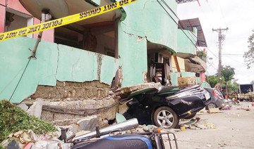
MANILA: A 6.3-magnitude quake rocked the Philippines Friday, the US Geological Survey said, with residents in the capital Manila reporting buildings shaking and Christmas Day masses interrupted but there were no reports of damage.
The quake struck in Batangas province on the main island of Luzon at a depth of 114 kilometers (70 miles) at 7:43 a.m. local time (2343 GMT), according to USGS.
The agency initially said the quake’s strength was 6.2 and 108 kilometers deep.
In the coastal city of Calatagan, about 90 kilometers south of Manila and near the epicenter, people attending mass remained calm as the earthquake hit, police chief Major Carlo Caceres told AFP.
“There was a pause in the church service, but the people did not panic,” Caceres said.
“This area is quake-prone and people are more or less used to them.”
There were no reports of damage or casualties in the area, he added.
“The office furniture and equipment swayed, but nothing was broken,” said policeman Allan Megano in the nearby town of Balayan.
The Philippines is situated on the Pacific “Ring of Fire,” an arc of intense seismic activity that stretches from Japan through Southeast Asia and across the Pacific basin.
![]()
![]()

6.3-magnitude earthquake rocks Philippines: USGS


Short Url
https://arab.news/4ff98
6.3-magnitude earthquake rocks Philippines: USGS
- Quake centered on Batangas province, south of Manila

Latest updates


© 2026 SAUDI RESEARCH & PUBLISHING COMPANY, All Rights Reserved And subject to Terms of Use Agreement.