Saudi Coffee Company set to share Jazan’s specialty coffee with the world
Saudi Coffee Company set to share Jazan’s specialty coffee with the world /node/2259756/saudi-arabia
Saudi Coffee Company set to share Jazan’s specialty coffee with the world
1 / 8
Saudi Arabia’s specialty Khawlani coffee will soon be reaching a wider audience, however, following last year’s launch of the PIF-owned Saudi Coffee Company (SCC). (Supplied)
2 / 8
Saudi Arabia’s specialty Khawlani coffee will soon be reaching a wider audience, however, following last year’s launch of the PIF-owned Saudi Coffee Company (SCC). (Supplied)
3 / 8
Saudi Arabia’s specialty Khawlani coffee will soon be reaching a wider audience, however, following last year’s launch of the PIF-owned Saudi Coffee Company (SCC). (Supplied)
4 / 8
Saudi Arabia’s specialty Khawlani coffee will soon be reaching a wider audience, however, following last year’s launch of the PIF-owned Saudi Coffee Company (SCC). (Supplied)
5 / 8
Saudi Arabia’s specialty Khawlani coffee will soon be reaching a wider audience, however, following last year’s launch of the PIF-owned Saudi Coffee Company (SCC). (Supplied)
6 / 8
Saudi Arabia’s specialty Khawlani coffee will soon be reaching a wider audience, however, following last year’s launch of the PIF-owned Saudi Coffee Company (SCC). (Supplied)
7 / 8
Saudi Arabia’s specialty Khawlani coffee will soon be reaching a wider audience, however, following last year’s launch of the PIF-owned Saudi Coffee Company (SCC). (Supplied)
8 / 8
Saudi Arabia’s specialty Khawlani coffee will soon be reaching a wider audience, however, following last year’s launch of the PIF-owned Saudi Coffee Company (SCC). (Supplied)
Saudi Coffee Company set to share Jazan’s specialty coffee with the world
Saudi Arabia produces one of the world’s finest coffees, known as Khawlani
Kingdom’s specialty coffee will soon be reaching a wider audience following last year’s launch of PIF-owned Saudi Coffee Company
Updated 28 February 2023
Arab News
JAZAN: If coffee has long been a significant element of Arabic life, with traditional pots kept constantly hot while serving small cups at social gatherings, then Saudi Arabia is upping the stakes and taking coffee culture to the next level.
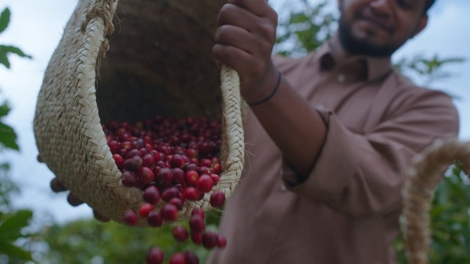
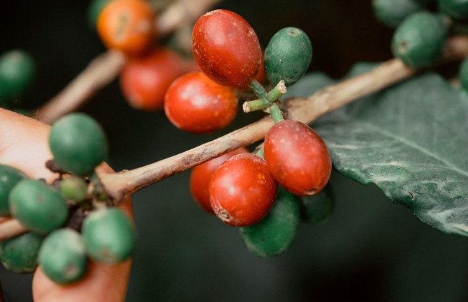
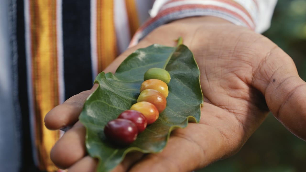
The country produces one of the world’s finest coffees, known as Khawlani, long recognized as the very best of the Arabica variety. It boasts low acidity, a complex tone and is slightly sweeter than regular coffee.
Reflecting Saudi Arabia’s strong sense of heritage and hospitality, the bean is named after the ancient Khawlan tribe, who have resided in the mountainous regions of Jazan and have been cultivating the bean for the past 500 years.
There are currently more than 2,500 Khawlani coffee plantations with a total of approximately 400,000 trees – although current production is mostly consumed locally.
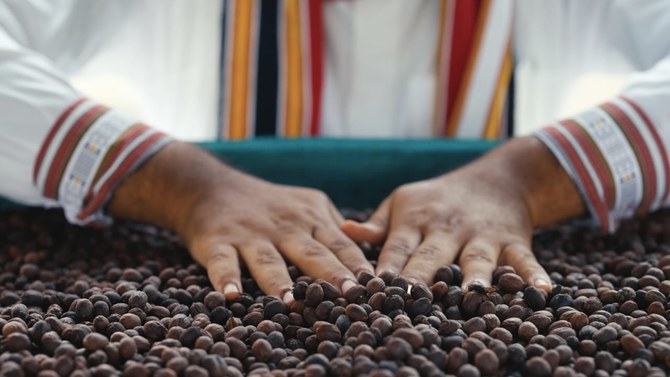
The people of the Khawlan Mountains in Jazan region were known for wearing a traditional costume known as "Akkawa"- a headband made of flowers- which combined the authentic dress with the prestigious Saudi coffee.
They also used a variety of tools to make coffee, such as “AlMihmas” which is a traditional pot used for roasting coffee, and the cooler which is used after the roasting process.
For grinding the beans, Khawlani people used niger and pestle to grind, and to serve coffee they used “Dallah” -a serving pot- and “Finjan” which a small coffee cup.
Sustainable investment
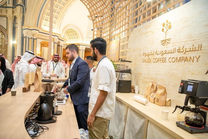
Saudi Arabia’s specialty coffee will soon be reaching a wider audience, however, following last year’s launch of the PIF-owned Saudi Coffee Company (SCC), which is investing in every stage of coffee production, from cultivation to cup.
As part of Vision 2030’s aim to diversify the economy, with a focus on sustainability, PIF launched SCC to localize coffee-related industries and enrich their contribution to Saudi Arabia’s domestic product through sustainable agriculture development efforts in the Jazan region.
Ultimately, with an investment of approximately SAR 1.2 billion over the next 10 years, SCC’s goal is to increase Saudi coffee output from 300 to 2,500 tons per year by creating jobs at every stage of the value chain.
Taking a sustainable approach throughout all stages of production – as well as distribution and marketing, SCC is enhancing the technology used in the production of coffee and upskilling local farmers.
To further support the farmers, SCC is launching an academy to train and qualify Saudi talents, and provide them with all the knowledge they need by helping them establish their own businesses and plantations in Jazan. SCC provides support to many Saudi farmers across the Jazan region. For instance, the company helps farmers with implementing new methods of cultivation and technologies in their own farms.
Additionally, the company aims to raise public awareness, locally and internationally, of the heritage and culture of Saudi Arabia’s coffee – including the types of coffee and their origins, the taste of each variety, and preparation methods.
With an estimated 73,000 tons of coffee currently imported to the Saudi market, SCC aims to boost local production and the private sector, partly through partnerships with small and medium-sized companies that are looking for opportunities for growth and expansion. This will create thousands of job opportunities for young people in the local coffee sector, and also support efforts to export Jazan coffee worldwide.
Connecting cultures
A variety of coffee cultivation and preparation methods is seen in different parts of Saudi Arabia. For instance, in the Najd region, coffee tends to be brown in color, while further south it tends to be lighter with a yellowish tone.
The ingredients for preparing coffee also vary, although all include the main ingredients of ground Saudi coffee beans, cardamom and saffron.
With coffee’s power to connect people and cultures, as well as support economies, SCC’s support of Saudi Arabia’s coffee sector will not only provide a path to a more sustainable industry locally, but is also set to seduce the rest of the world with its specialty coffee.
DUBAI: Across the deserts and mountain valleys of the Arab world, drones are now doing work that once took teams of archaeologists months to complete.
In northern Saudi Arabia, for example, aerial surveys can map an entire ancient settlement in minutes, revealing faint outlines of walls, pathways and structures hidden beneath the surface.
These images are later turned into 3D models — part of a growing effort across the region to use technology to trace old trade routes, map forgotten sites and better understand how people once moved across Arabia and beyond.
Much of this work is connected to renewed interest in the Silk Road and the networks that once linked Arabia with the wider world.
Harrat, Khaybar. (Supplied)
The Silk Road refers to a network of ancient trade routes that linked East Asia with the Middle East, North Africa and Europe for more than 1,500 years.
Rather than a single road, it was a vast web of caravan paths and maritime corridors connecting cities from China and Central Asia to Iran, Iraq, the Arabian Peninsula, the Levant and the Mediterranean.
Along these routes, merchants, scholars and travelers exchanged goods such as silk, spices and metalwork, as well as ideas, technologies and cultural traditions that shaped the development of the wider region.
In more recent times, scholars, students and heritage authorities across the Middle East and Central Asia are increasingly relying on drones, laser scanning, photogrammetry and satellite analysis to document archaeological landscapes.
In Saudi Arabia’s AlUla and Khaybar regions — now considered some of the world’s densest concentrations of prehistoric and Bronze Age structures — drone surveys have helped researchers record sites that would otherwise remain inaccessible.
Dr. Hugh Thomas, a lecturer in archaeology at the University of Sydney and co-director of the Prehistoric AlUla and Khaybar Excavation Project, says the scale of the Saudi landscape makes aerial work essential.
“Saudi Arabia contains an exceptionally dense archaeological landscape distributed across a vast geographic area,” he told Arab News. “Drone-based surveys allow large volumes of archaeological data to be collected efficiently.”
A Neolithic mustatil next to a Bronze Age pendant burial in Kaybar. (Supplied/Mat Dalton)
Indeed, many structures sit on steep or remote terrain that ground teams cannot easily reach. This shift to aerial archaeology has also revealed details that would be almost impossible to see from ground level.
Thomas notes that researchers have long suspected a link between water sources and Neolithic mustatil structures, which date back approximately 7,000 years. In 2020, drone images captured by his team near Khaybar also strengthened theories linking mustatil to water sources.
“The drone images revealed that recent rains had settled in specific parts of wadi valleys, exactly where the mustatil were built,” he said. Since then, multiple surveys and peer-reviewed studies have supported this connection, with many mustatil shown to point directly toward water.
In parallel, new technologies are reshaping how archaeologists understand the wider landscape. Thomas says tools such as drones, satellite imagery and 3D modelling allow researchers to document vast areas quickly and at far higher resolution than ever before.
These approaches “enable the rapid, cost-effective documentation of this vast and previously understudied landscape” and create permanent digital records that support long-term monitoring and analysis, he said.
This has been transformative for understanding past movement and land use.
Remote sensing work in northern Saudi Arabia has revealed extensive Bronze Age funerary avenues — pathways lined with monumental tombs, running for thousands of kilometers and linking major oases such as Khaybar, Al-Hait and Al-Huwayyitt.
Drone surveys and 3D models have allowed researchers to classify tomb types more accurately and identify where excavation would yield the most useful results. Thomas says these techniques directly contributed to one of the project’s most significant achievements.
“This has ultimately assisted us with our most recent paper, where we were able to publish the C14 dates of remains found in 40 Bronze Age tombs, helping us understand when these tombs appeared on the landscape and how they developed over time,” he said.
While international collaborations play a central role, Thomas says long-term progress in the Kingdom depends on building local capacity.
He says contributions from Saudi researchers, students and even members of the public are becoming increasingly important.
Archaeologist Don Boyer measures a tower of stones next to a 525m long Mustatil in Khaybar. (David Kennedy)
“Local researchers, students, and members of the public are taking photographs of archaeological sites and sharing them digitally,” he said. “Each image provides a lasting record of archaeological remains.”
In Saudi Arabia’s AlUla, one of the region’s most active archaeological hubs, the Royal Commission for AlUla has supported wide-ranging surveys that combine aerial photography, remote sensing and targeted excavation.
Published research from the AlUla and Khaybar Aerial Archaeology Project describes how thousands of structures — from ancient hunting traps to tombs and settlements — have been recorded using these methods in recent years.
“We’re seeing landscapes we did not even know existed before this kind of work began,” said archaeologist Dr. Rebecca Repper of the University of Sydney in an RCU briefing.
“Technology is helping us reassess northern Arabia’s role in long-distance connections.”
Recent research across Central Asia shows how drones and LiDAR, a remote-sensing technology used to create extremely accurate 3D maps of landscapes, buildings, or buried features, are transforming the study of Silk Road-era landscapes.
In Uzbekistan, a team led by Dr. Michael Frachetti — an archaeologist at Washington University in St. Louis, who specializes in ancient mobility systems — used drone-mounted LiDAR to scan remote high-altitude terrain, revealing two previously undocumented medieval cities, Tugunbulak and Tashbulak.
Researchers excavate medieval pottery at the newly rediscovered medieval Silk Road city Tugunbulak located in the mountains of southeastern Uzbekistan June 8, 2022 (Michael Frachetti)
A 2024 peer-reviewed study, “Automated analysis of high-resolution lidar traces large-scale medieval urbanism in highland Central Asia,” details how these surveys exposed plazas, fortifications and settlement layouts previously invisible from the ground.
In southeast Kazakhstan, a 2021 study in the journal Applied Sciences shows how UAV photogrammetry helped map irrigation networks, settlement traces and burial mounds linked to medieval trade and pastoral routes.
Together, these findings demonstrate how high-resolution aerial mapping is reshaping our understanding of the landscapes and movement patterns that framed the Silk Road.
For governments, these discoveries are more than scientific. UNESCO describes the Silk Roads as a shared heritage space where cooperation is critical, and regional countries have increasingly embraced cross-border research partnerships.
In Saudi Arabia, AlUla’s collaborations with universities including Oxford, Bologna and the French National Centre for Scientific Research reflect a growing diplomatic interest in cultural research.
These partnerships have generated shared excavations, joint field schools and open-access databases — opportunities that were rare in the region two decades ago.
Digital access is also reshaping how the public engages with this history.
The International Dunhuang Project, a global consortium led by the British Library and multiple Asian national libraries, has digitized hundreds of thousands of manuscripts, murals and archaeological fragments linked to the Silk Road.
Its open platform has become a major educational resource for schools and researchers worldwide.
A LiDAR image of Tugunbulak shows a dense settlement along a ridge. (Michael Frachetti)
In AlUla, digital reconstructions and virtual models are increasingly used in classroom activities and community programs.
Youth involvement is part of this shift. In Saudi Arabia, RCU’s assorted heritage guardian programs introduce young people to survey techniques, basic archaeology and remote-sensing tools, helping train a new generation of community researchers.
In parts of Central Asia, student volunteers often support field surveys and digital documentation under national heritage ministries and international missions.
Across deserts, mountains and oasis towns, a fuller picture of ancient networks is beginning to emerge. Every drone flight reveals structures long buried under sand and stone.
“On the plateau, we found a hidden valley with large mounds and undulations on the surface,” Frachetti explained in a Washington University Magazine feature about his team’s drone-assisted work.
“It was obvious, both in person and on the drone-acquired surface model we created, that we had stumbled across something much larger and different from the typical campsite we had expected.”
Recent archaeological work has discovered a fortified 2.6-hectares Bronze Age town (al Natah) in Khaybar oasis (dating around 2400 BCE- 1300 BCE). (RCU)
Meanwhile, every 3D model helps trace how people once traveled, traded and settled across continents.
And every partnership — whether in AlUla, the Gulf, or Central Asia — reinforces the idea that this heritage connects far more than a single nation.
The Silk Road’s story is being rediscovered not through speculation but through data, satellites and the work of a generation that is documenting the past with new precision.