New launch attempt Saturday for NASA’s Moon rocket: official

NASA's Space Launch System (SLS) rocket with the Orion spacecraft aboard is seen atop the mobile launcher at Launch Pad 39B, Tuesday, Aug. 30, 2022, in Cape Canaveral, Fla.. (AP)
Short Url
Updated 31 August 2022
Follow

New launch attempt Saturday for NASA’s Moon rocket: official

  • The goal of Artemis 1, named after the twin sister of Apollo, is to test the 322-foot (98-meter) Space Launch System rocket and Orion crew capsule that sits on top

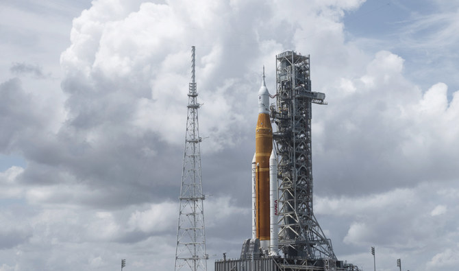
CAPE CANAVERAL, Florida: NASA will try again Saturday to launch its new moon rocket on a test flight, after engine trouble halted the first countdown this week.
Managers said Tuesday they are changing fueling procedures to deal with the issue. A bad sensor also could be to blame for Monday’s scrapped launch, they noted.
The 322-foot (98-meter) rocket — the most powerful ever built by NASA — remains on its pad at Kennedy Space Center with an empty crew capsule on top.
The Space Launch System rocket will attempt to send the capsule around the moon and back. No one will be aboard, just three test dummies. If successful, it will be the first capsule to fly to the moon since NASA’s Apollo program 50 years ago.
Proceeding toward a Saturday launch will provide additional insight, even if the problem reappears and the countdown is halted again, said NASA’s rocket program manager, John Honeycutt. That’s better “than us sitting around scratching our heads, was it good enough or not.”


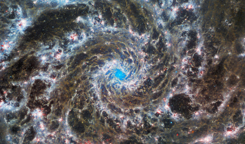
This photo released by NASA/ESA on August 30, 2022 from the James Webb Space Telescope and the Hubble Space Telescope shows the heart of M74, otherwise known as the Phantom Galaxy. (AFP)

“Based on what I’ve heard from the technical team today, what we need to do is continue to pore over the data and polish up our plan on putting the flight rationale together,” he said.
During Monday’s launch attempt, readings showed that one of the four main engines in the rocket’s core stage could not be chilled sufficiently prior to the planned ignition at liftoff. It appeared to be as much as 40 degrees Fahrenheit (5 degrees Celsius) warmer than the desired minus-420 degrees Fahrenheit (minus-250 degrees Celsius), the temperature of the hydrogen fuel, according to Honeycutt. The three other engines came up just a little short.
All of the engines appear to be fine, according to Honeycutt.
The chilling operation will be conducted a half-hour earlier for Saturday afternoon’s launch attempt, once fueling begins that morning. Honeycutt said the timing of this engine chilldown was earlier during successful testing last year, and so performing it sooner may do the trick.
Honeycutt also questioned the integrity of one engine sensor, saying it might have provided inaccurate data Monday. To change that sensor, he noted, would mean hauling the rocket back into the hangar, resulting in weeks of delay.
Already years behind schedule, the $4.1 billion test flight is the opening shot in NASA’s Artemis moon-exploration program, named after the twin sister of Apollo in Greek mythology. Astronauts could strap in as soon as 2024 for a lap around the moon and actually attempt a lunar landing in 2025.


Winter storm packing snow and strong winds to descend on Great Lakes, Northeast

Updated 30 December 2025
Follow

Winter storm packing snow and strong winds to descend on Great Lakes, Northeast

  • The fierce winds on Lake Erie sent water surging toward the basin’s eastern end near Buffalo, New York, while lowering water on the western side in Michigan to expose normally submerged lakebed — even the wreck of a car and a snowmobile

NEW YORK: A wild winter storm was expected to bring strong winds, heavy snow and frigid temperatures to the Great Lakes and Northeast on Tuesday, a day after a bomb cyclone barreled across the northern US and left tens of thousands of customers without power.
The storm that hit parts of the Plains and Great Lakes on Monday brought sharply colder air, strong winds and a mix of snow, ice and rain, leading to treacherous travel. Forecasters said it intensified quickly enough to meet the criteria of a bomb cyclone, a system that strengthens rapidly as pressure drops.
Nationwide, more than 127,000 customers were without power Tuesday morning, more than a third of them in Michigan, according to Poweroutage.us.

BACKGROUND

The storm that hit parts of the Plains and Great Lakes on Monday brought sharply colder air, strong winds and a mix of snow, ice and rain, leading to treacherous travel.

As the storm moved into Canada, the National Weather Service predicted more inclement weather conditions for the Eastern US, including quick bursts of heavy snow and gusty winds known as snow squalls. Blustery winds were expected to add to the arctic chill, with low temperatures dipping below freezing as far south as the Florida panhandle, the agency said.
New York Gov. Kathy Hochul warned that whiteout conditions were expected Tuesday in parts of the state, including the Syracuse metro area.
“If you’re in an impacted area, please avoid all unnecessary travel,” she said in a post on the social platform X.
Snow piled up quickly in Michigan’s Upper Peninsula on Monday, where as much as 2 feet (60 centimeters) fell in some areas, according to the National Weather Service. Meteorologist Ryan Metzger said additional snow was expected in the coming days, although totals would be far lighter.
Waves on Lake Superior that were expected to reach 20 feet (6 meters) on Monday sent all but one cargo ship into harbors for shelter, according to MarineTraffic.com.
The fierce winds on Lake Erie sent water surging toward the basin’s eastern end near Buffalo, New York, while lowering water on the western side in Michigan to expose normally submerged lakebed — even the wreck of a car and a snowmobile.
Kevin Aldrich, 33, a maintenance worker from Monroe, Michigan, said he has never seen the lake recede so much and was surprised on Monday to spot remnants of piers dating back to the 1830s. He posted photos on social media of wooden pilings sticking up several feet from the muck.
“Where those are at would typically be probably 12 feet deep,” he said. “We can usually drive our boat over them.”
Dangerous wind chills plunged as low as minus 30 F (minus 34 C) across parts of North Dakota and Minnesota on Monday. And in northeast West Virginia, rare, nearly hurricane-force winds were recorded on a mountain near Dolly Sods, according to the National Weather Service.
In Iowa, after blizzard conditions eased by Monday morning, high winds continued blowing snow across roadways, keeping more than 200 miles (320 kilometers) of Interstate 35 closed. State troopers reported dozens of crashes during the storm, including one that killed a person.
On the West Coast, the National Weather Service warned that moderate to strong Santa Ana winds were expected in parts of Southern California through Tuesday, raising concerns about downed trees in areas where recent storms had saturated the soil. Two more storms were forecast later this week, with rain on New Year’s Day potentially soaking the Rose Parade in Pasadena for the first time in about two decades.