Israel calls for evacuations from south Lebanon, explosions in Beirut

A man stands amid the damage caused by Israeli airstrikes, as smokes rises over Beirut southern suburbs at Choueifat district, in Beirut on Oct. 3, 2024. (Reuters)
Short Url
Updated 03 October 2024
Follow

Israel calls for evacuations from south Lebanon, explosions in Beirut

  • The call for evacuations from southern towns included the provincial capital Nabatieh
  • “Only that uncertainty lies ahead. Anxiety and fear are omnipresent,” UN special coordinator in Lebanon, Jeanine Hennis-Plasschaert, said

BEIRUT/JERUSALEM: Israel’s military urged residents of over 20 towns in south Lebanon to evacuate their homes immediately on Thursday as it pressed on with an incursion after suffering its worst losses in a year of fighting the Iran-backed armed group Hezbollah.
The call for evacuations from southern towns included the provincial capital Nabatieh, suggesting another Israeli operation designed to further weaken Hezbollah is imminent.
Israel, which has been fighting with Hamas in Gaza for almost a year, sent its troops into southern Lebanon after two weeks of intense airstrikes, escalating tensions in a conflict that risks drawing in the United States and Iran.
In Beirut’s southern suburb, a Hezbollah stronghold, three explosions were heard on Thursday and several large plumes of smoke were rising after heavy Israeli strikes.
While Hezbollah said it detonated an improvised explosive device against Israeli forces infiltrating a southern Lebanese village.
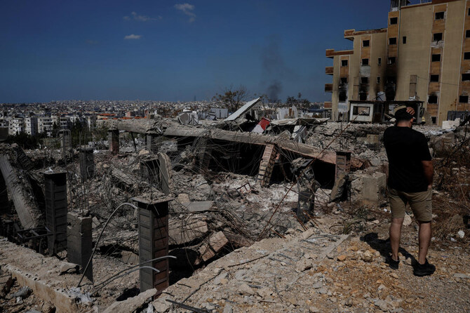
Overnight, Israel bombed central Beirut in an attack the Lebanese health ministry said killed nine people.
Reuters witnesses reported hearing a massive blast, which a security source said had targeted a building in the district of Bachoura a few hundred meters from parliament, the closest an Israeli strike has come to the central downtown district.
“Another sleepless night in Beirut. Counting the blasts shaking the city. No warning sirens. Not knowing what’s next. Only that uncertainty lies ahead. Anxiety and fear are omnipresent,” UN special coordinator in Lebanon, Jeanine Hennis-Plasschaert, said on X on Thursday.


A Hezbollah-linked civil defense group said seven of its staff, including two medics, had been killed in the Beirut attack, which Israel said was a “precise” airstrike.
Israel also said it targeted a municipality building in the southern Lebanese town of Bint Jbeil killing 15 Hezbollah members, while more than a dozen Israeli missiles also hit the southern suburb of Dahiyeh, where Hezbollah leader Hassan Nasrallah was killed last week.
Eight Israeli soldiers were killed in ground combat on Wednesday in south Lebanon as its forces thrust into its northern neighbor.
As it pushes into south Lebanon, Israel is also weighing its options for retaliation against its arch-foe Iran.

ISRAEL, US VOW TO STRIKE BACK
The Islamic Republic launched its largest ever assault on Israel on Tuesday in what it said was retaliation for Israel’s assassination of senior Hamas and Hezbollah leaders and its operations in Gaza and Lebanon.
On Thursday, Israel’s military said it had “eliminated” Rawhi Mushtaha, the head of the Hamas government in Gaza, along with senior security officials Sameh Al-Siraj and Sami Oudeh in strikes three months ago.
Tehran said its attack was over, barring further provocation, but Israel and the United States have promised to hit back hard.
Iranian President Masoud Pezeshkian, speaking at an event in Doha, said Iran would be ready to respond and warned against “silence” in the face of Israel’s “warmongering.”
“Any type of military attack, terrorist act or crossing our red lines will be met with a decisive response by our armed forces.” Qatar’s Emir Sheikh Tamim bin Hamad Al-Thani called for serious ceasefire efforts to stop Israel’s “aggression” in Lebanon and said no peace was possible in the Middle East without the creation of a Palestinian state.
What is happening in the Middle East is a “collective genocide” he said at the same Doha event, adding that his country has always warned of Israel’s “impunity.”
The Lebanese border front opened after Hezbollah fired missiles at Israel on Oct. 8 in support of Hamas in its war with Israel in Gaza.
Iran’s other regional allies — Yemen’s Houthis and armed groups in Iraq — have also launched attacks in the region in support of Hamas.
The Houthis, who have been firing missiles, sending armed drones and launching boats laden with explosives at commercial ships with ties to Israeli, US and UK entities since last year, said they launched a successful attack on Israel’s commercial capital Tel Aviv with drones. Israel said it intercepted a suspicious aerial target in the area of central Israel early on Thursday.
SHELTERING IN A NIGHTCLUB More than 1,900 people have been killed and over 9,000 wounded in Lebanon in almost a year of cross-border fighting, with most of the deaths occurring in the past two weeks, according to Lebanese government statistics.
Caretaker Prime Minister Najib Mikati said about 1.2 million Lebanese had been displaced by Israeli attacks.
More than 300 of those displaced have taken shelter in a Beirut nightclub, once known for hosting glitzy parties and where staff are now using their guest-list clipboards to register residents.
“We’re trying to keep strong,” said Gaelle Irani, who was formerly in charge of guest relations, taking a brief break from finding people a corner to live in.
“It’s just overwhelming. So overwhelming and sad. But just as this was a place for people to come enjoy themselves, it’s now a place to shelter people and we are doing everything we can to help and be there for them.”
Hassan Shaaban, a fisherman from Sidon, said he has been struggling to make a living as the fighting rages.
“What can we do, we need to be able to live, we are working while they are striking, yesterday night was very intense,” he said.


What new technologies are revealing about the Silk Road’s forgotten landscapes

Updated 7 sec ago
Follow

What new technologies are revealing about the Silk Road’s forgotten landscapes

  • Drones and digital tools are allowing archaeologists to map vast areas in hours rather than months of ground surveys
  • In Saudi Arabia, aerial mapping has uncovered dense prehistoric and Bronze Age sites previously thought to be empty

DUBAI: Across the deserts and mountain valleys of the Arab world, drones are now doing work that once took teams of archaeologists months to complete.

In northern Saudi Arabia, for example, aerial surveys can map an entire ancient settlement in minutes, revealing faint outlines of walls, pathways and structures hidden beneath the surface.

These images are later turned into 3D models — part of a growing effort across the region to use technology to trace old trade routes, map forgotten sites and better understand how people once moved across Arabia and beyond.

Much of this work is connected to renewed interest in the Silk Road and the networks that once linked Arabia with the wider world.

The Silk Road refers to a network of ancient trade routes that linked East Asia with the Middle East, North Africa and Europe for more than 1,500 years.

Rather than a single road, it was a vast web of caravan paths and maritime corridors connecting cities from China and Central Asia to Iran, Iraq, the Arabian Peninsula, the Levant and the Mediterranean.

Along these routes, merchants, scholars and travelers exchanged goods such as silk, spices and metalwork, as well as ideas, technologies and cultural traditions that shaped the development of the wider region.

In more recent times, scholars, students and heritage authorities across the Middle East and Central Asia are increasingly relying on drones, laser scanning, photogrammetry and satellite analysis to document archaeological landscapes.

In Saudi Arabia’s AlUla and Khaybar regions — now considered some of the world’s densest concentrations of prehistoric and Bronze Age structures — drone surveys have helped researchers record sites that would otherwise remain inaccessible.

Dr. Hugh Thomas, a lecturer in archaeology at the University of Sydney and co-director of the Prehistoric AlUla and Khaybar Excavation Project, says the scale of the Saudi landscape makes aerial work essential.

“Saudi Arabia contains an exceptionally dense archaeological landscape distributed across a vast geographic area,” he told Arab News. “Drone-based surveys allow large volumes of archaeological data to be collected efficiently.” 

Indeed, many structures sit on steep or remote terrain that ground teams cannot easily reach. This shift to aerial archaeology has also revealed details that would be almost impossible to see from ground level.

Thomas notes that researchers have long suspected a link between water sources and Neolithic mustatil structures, which date back approximately 7,000 years. In 2020, drone images captured by his team near Khaybar also strengthened theories linking mustatil to water sources.

“The drone images revealed that recent rains had settled in specific parts of wadi valleys, exactly where the mustatil were built,” he said. Since then, multiple surveys and peer-reviewed studies have supported this connection, with many mustatil shown to point directly toward water.

In parallel, new technologies are reshaping how archaeologists understand the wider landscape. Thomas says tools such as drones, satellite imagery and 3D modelling allow researchers to document vast areas quickly and at far higher resolution than ever before.

These approaches “enable the rapid, cost-effective documentation of this vast and previously understudied landscape” and create permanent digital records that support long-term monitoring and analysis, he said.

This has been transformative for understanding past movement and land use.

Remote sensing work in northern Saudi Arabia has revealed extensive Bronze Age funerary avenues — pathways lined with monumental tombs, running for thousands of kilometers and linking major oases such as Khaybar, Al-Hait and Al-Huwayyitt.

Drone surveys and 3D models have allowed researchers to classify tomb types more accurately and identify where excavation would yield the most useful results. Thomas says these techniques directly contributed to one of the project’s most significant achievements.

“This has ultimately assisted us with our most recent paper, where we were able to publish the C14 dates of remains found in 40 Bronze Age tombs, helping us understand when these tombs appeared on the landscape and how they developed over time,” he said.

While international collaborations play a central role, Thomas says long-term progress in the Kingdom depends on building local capacity.

He says contributions from Saudi researchers, students and even members of the public are becoming increasingly important.

“Local researchers, students, and members of the public are taking photographs of archaeological sites and sharing them digitally,” he said. “Each image provides a lasting record of archaeological remains.”

In Saudi Arabia’s AlUla, one of the region’s most active archaeological hubs, the Royal Commission for AlUla has supported wide-ranging surveys that combine aerial photography, remote sensing and targeted excavation.

Published research from the AlUla and Khaybar Aerial Archaeology Project describes how thousands of structures — from ancient hunting traps to tombs and settlements — have been recorded using these methods in recent years.

“We’re seeing landscapes we did not even know existed before this kind of work began,” said archaeologist Dr. Rebecca Repper of the University of Sydney in an RCU briefing. 

“Technology is helping us reassess northern Arabia’s role in long-distance connections.”

Recent research across Central Asia shows how drones and LiDAR, a remote-sensing technology used to create extremely accurate 3D maps of landscapes, buildings, or buried features, are transforming the study of Silk Road-era landscapes.

In Uzbekistan, a team led by Dr. Michael Frachetti — an archaeologist at Washington University in St. Louis, who specializes in ancient mobility systems — used drone-mounted LiDAR to scan remote high-altitude terrain, revealing two previously undocumented medieval cities, Tugunbulak and Tashbulak.

A 2024 peer-reviewed study, “Automated analysis of high-resolution lidar traces large-scale medieval urbanism in highland Central Asia,” details how these surveys exposed plazas, fortifications and settlement layouts previously invisible from the ground.

In southeast Kazakhstan, a 2021 study in the journal Applied Sciences shows how UAV photogrammetry helped map irrigation networks, settlement traces and burial mounds linked to medieval trade and pastoral routes.

Together, these findings demonstrate how high-resolution aerial mapping is reshaping our understanding of the landscapes and movement patterns that framed the Silk Road.

For governments, these discoveries are more than scientific. UNESCO describes the Silk Roads as a shared heritage space where cooperation is critical, and regional countries have increasingly embraced cross-border research partnerships.

In Saudi Arabia, AlUla’s collaborations with universities including Oxford, Bologna and the French National Centre for Scientific Research reflect a growing diplomatic interest in cultural research.

These partnerships have generated shared excavations, joint field schools and open-access databases — opportunities that were rare in the region two decades ago.

Digital access is also reshaping how the public engages with this history.

The International Dunhuang Project, a global consortium led by the British Library and multiple Asian national libraries, has digitized hundreds of thousands of manuscripts, murals and archaeological fragments linked to the Silk Road.

Its open platform has become a major educational resource for schools and researchers worldwide.

In AlUla, digital reconstructions and virtual models are increasingly used in classroom activities and community programs.

Youth involvement is part of this shift. In Saudi Arabia, RCU’s assorted heritage guardian programs introduce young people to survey techniques, basic archaeology and remote-sensing tools, helping train a new generation of community researchers.

In parts of Central Asia, student volunteers often support field surveys and digital documentation under national heritage ministries and international missions.

Across deserts, mountains and oasis towns, a fuller picture of ancient networks is beginning to emerge. Every drone flight reveals structures long buried under sand and stone.

“On the plateau, we found a hidden valley with large mounds and undulations on the surface,” Frachetti explained in a Washington University Magazine feature about his team’s drone-assisted work.

“It was obvious, both in person and on the drone-acquired surface model we created, that we had stumbled across something much larger and different from the typical campsite we had expected.”

Meanwhile, every 3D model helps trace how people once traveled, traded and settled across continents.

And every partnership — whether in AlUla, the Gulf, or Central Asia — reinforces the idea that this heritage connects far more than a single nation.

The Silk Road’s story is being rediscovered not through speculation but through data, satellites and the work of a generation that is documenting the past with new precision.